Extensive changes in land ownership and land management
have occurred in Alaska over the past 20 years. Many areas, previously
open to general public use, are now included in a federal conservation
unit, state legislatively designated unit, or have been conveyed
to a Native corporation or other private party. Public use of these
areas may now be restricted or no longer available.
These recent changes in land ownership and management
have resulted in a growing problem: the unauthorized use of land
and resources. The purpose of this atlas is to aid the public and
the land owners in dealing with this problem. Most unauthorized
use has been inadvertent, resulting from a lack of readily available
and easily understood land status information. This atlas provides
current land ownership and public use information, including use
restrictions on the date of publication.
This atlas is not a legal document. It is a representation
of official federal, state, municipal and private land records.
For complete information on land ownership, contact the State Recorders
Office or the apparent land owner. Official land status records
are also available at government offices listed in this atlas.
You may need to Contact several offices to obtain a complete picture
of the area you are interested in.
All land owned by Native corporations is private
land. Except as specifically noted, it is closed to public use,
just like any other private land, unless the user obtains permission
of the land owner. Certain lands, owned by Native corporations,
are subject to specifically located easements, as described, in
the atlas, that allow the public to use those identified Native
corporation lands in limited ways.
In addition, some of the lands conveyed to Native
corporations are open to sport hunting and fishing and other recreational
uses by the public. These lands are specifically identified on
the maps. Even these lands are subject to such reasonable restrictions
as may be imposed by the Native corporation landowners, for the
purposes of limiting or prohibiting such public uses in the immediate
vicinity of logging or other commercial operations. Active timber
harvesting operations are ongoing on Afognak Island. As a result,
the Native corporation landowners may close portions of Afognak
Island to public use. Users should obey all signs or barricades.
This atlas tells who owns the land (as of March
1997), who to contact, where public access easements are located,
and the kinds of activities allowed on each easement. We recommend
that readers who are unfamiliar with land management terminology,
review the Glossary before continuing.
Be aware that within state and
federal parks, game refuges and sanctuaries, critical habitat
areas, and "special
use land" areas, there are additional restrictions
on uses and activities allowed on the land. Permits or special
authorizations
may be required for certain uses in these areas.
For information on generally allowed uses and activities
on state land, that is not in any special management category or
status, contact the Public Information Office at the Department
of Natural Resources listed in this atlas.
Except as provided for by a public access easement,
private land is not open to public use without prior permission
from the landowner. Use of private land or use of a public casement
for an unauthorized purpose, without obtaining prior permission
from the landowner may constitute trespass.
Contact the appropriate landowner if you have any
questions concerning public use of an area. Obtain permission and
any necessary permits in advance. A list of landowners is included
in this atlas. Always contact the landowner for updated rules and
regulations before conducting any activity.
Cabins and tent camps, used for trapping, fishing,
hunting, mining, and other purposes, are essential to the livelihood
of many rural residents. Only in a real emergency should the public
use someone else's cabin or camp. A cabin or camp may appear abandoned
but the owner probably will return and will need everything in
the cabin or camp during the coming season. Alaska's pioneers established
the honorable tradition of respecting cabins and campsites. Please
continue with this tradition.
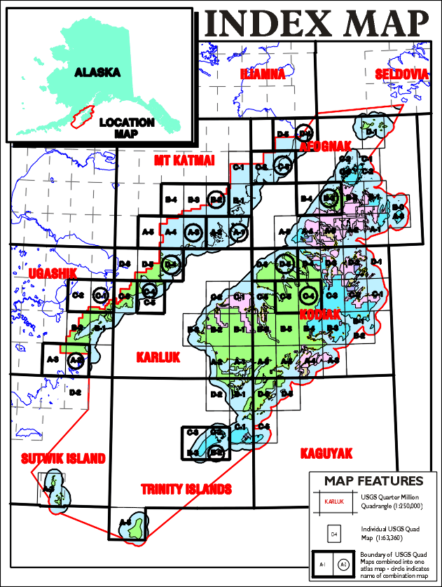
View the map below to determine which USGS quad map
you are interested in. Then click on the map name in the table
below the map to view the map(s) or text in PDF format.
NOTE: Each
PDF file consists of a map or maps, and the text page
or pages for that quad; in some cases 2 or 3 quads combined.
You must set the View in Acrobat Reader to Facing Pages,
or scroll down to see the map, or use the arrow buttons on the navigation
bar to be sure you view all the pages in each file. In the lower left
hand corner of the Acrobat Reader screen, is a box that tells you
how many pages are in that document, and which page is currently shown,
example: Page 1 of 2, or Page 2 of 3, etc.